Editor’s Note: This story will be updated periodically as the event develops.
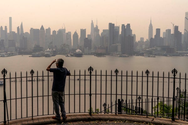
An eerie, orange-lit haze has provided an unusual backdrop to the iconic Manhattan skyline as one of the region’s worst air pollution events in decades descended on New York City, courtesy of smoke pouring southward from wildfires raging across Canada. It is yet another apocalyptic scene from our climate-changed world.
“I am concerned about what this means for the rest of the season,” says Christine Wiedinmyer, an atmospheric chemist at the Cooperative Institute for Research in Environmental Sciences at the University of Colorado Boulder. “We’re only in June—early June. And so there’s a possibility that we could be in for a smoky summer across the country.”
On supporting science journalism
If you're enjoying this article, consider supporting our award-winning journalism by subscribing. By purchasing a subscription you are helping to ensure the future of impactful stories about the discoveries and ideas shaping our world today.
But even though the fires may well keep raging through the summer, their smoke might not bedevil quite as many people as the current smoke has. This possibility for optimism is linked to changing weather patterns that may keep smoke closer to the fires that create it, says Greg Carbin, chief of forecast operations at the U.S. National Weather Service’s Weather Prediction Center. “The smoke is very, very tricky as far as trajectory forecasts for a longer term,” Carbin notes. That said, “as we go into summer and the jet stream weakens across the continental United States, it’s likely we’ll see a slow diminishing of the problems we’re seeing with the smoke from Canada.”
Canada has had the worst start to its fire season on record, with more than nine million acres burned so far this year—about the size of Massachusetts and Connecticut combined. More than 400 blazes are currently spewing smoke into the atmosphere across the country, with more than 200 of them raging out of control. Hot and dry weather conditions have left forests across Canada primed to burn. The blazes started out west in Alberta and British Columbia this spring and worsened during a major heat dome event in May. Smoke from those fires swept down into the western U.S., causing air quality to plummet in Montana and Colorado.
Then fires erupted farther east in Nova Scotia and Quebec, with authorities ordering many communities to evacuate. The result has been a brutal start to the fire season.
“We haven’t seen a year where the area burned has increased so rapidly so early in the spring,” says Richard Carr, a fire research analyst with Natural Resource Canada’s Canadian Forest Service. Although large spring fires aren’t unheard of, he says, having so many in one year is rare. Canada’s largest fire year to date was 1989, he says, when early spring fires devastated Manitoba. “We’re getting close to about halfway up to that record so far, and we’ve still got a few months of possible fire season left,” Carr says.
Once all that smoke is in the atmosphere, its fate depends on prevailing weather patterns. The fires have been fed in part by a big, high-pressure system that’s stubbornly lingered over Canada for weeks now in what atmospheric scientists call a blocking pattern, keeping temperatures high and precipitation low. Along the eastern edge of that block, Carbin says, a low-pressure system has formed in the Northeast. Air circulating around and between those two systems is pulling the smoke southward over the Great Lakes, the Northeast and the mid-Atlantic region. “Any particulate matter that's generated by these fires in Canada is basically going to stream to the south,” Carbin says.
Precisely where the smoke ends up can change dramatically, depending on how the wind is blowing. “It can shift very subtly,” Carbin says. “It can just be a small shift, and one day can be a real smoky, bad day for air quality—and the next day could be fine because you can incorporate drier, cooler, less polluted air.” That’s why northern New England, although closer to the fires, currently has much cleaner air than New York State and the mid-Atlantic coast, he says.
How high in the atmosphere wildfire smoke is matters too, Wiedinmyer says. “Sometimes it stays high up in the air, but this time it’s coming down to the surface where we work and live and breathe, so it’s not impacting just our visibility,” she says. With the current weather patterns, “smoke is actually getting down to the surface, and the concentrations of those particles are so high,” Wiedinmyer says. “The levels of particles at the surface are very, very high, and very uncommon.”
In New York City, air quality measurements were among the worst on record because of high levels of the particulate matter that scientists call PM2.5. These are fine particles that have a diameter of 2.5 microns or smaller—tiny enough to travel deep into the respiratory system. They are particularly harmful for the very young, the elderly and those with certain medical conditions such as asthma and heart disease.According to scientists with Stanford University’s Environmental Change and Human Outcomes Lab, Wednesday was the worst wildfire smoke day in the U.S. since 2006 in terms of the number of people exposed. More than 60 million people experienced concentrations of PM2.5 above 60 micrograms per cubic meter (µg/m3). More than 47 million people were exposed to levels above 75 µg/m3. The U.S. Environmental Protection Agency sets safe levels at 12.0 µg/m3. Levels on the streets of New York City rose above 400 µg/m3 during the worst of the event.
Although New York State and parts of New England saw the densest smoke on Wednesday, that plume had shifted south by Thursday, looming over the region stretching from Philadelphia to Washington, D.C. Smoke from the fires had also drifted as far south as Georgia, though air quality there was not nearly as bad as farther north.
People in smoke-affected areas are advised not to do strenuous exercise outdoors and to wear masks outdoors where air pollution levels are particularly bad. Closing windows and running air purifiers can help improve indoor air quality.
Smoke can also foster fire-friendly conditions, Carbin says. “In the summer months the bulk of precipitation we get is from thunderstorms. And for thunderstorms to form, you need surface heating—and you will reduce surface heating in the presence of thick smoke” because it blocks solar rays, Carbin says. “So there is a relationship between the amount of smoke and the amount of precipitation.”
Carr says that some forecasts show the high-pressure block over Canada weakening next week, which could offer the nation a respite. But even that might not be enough to calm the fires. “We’re really looking to see a big storm system that could stay parked for a couple of days” and bring needed rain, Carr says. “That’d be very helpful, we’re just not seeing that type of system yet.”
In the longer term, Carr says that a developing El Niño pattern in the global climate may ease conditions, reducing temperatures and increasing precipitation across southern Canada, although it may take several months for the effect to build up. “For the rest of the season, it’s a tough call,” Carr says.
But even if Canada’s fires remain dire, Carbin says, smoky conditions along the mid-Atlantic coast may not last as summer begins, thanks to changing weather patterns across North America. This particularly involves the jet stream: the fast-moving air current in the atmosphere that transports weather systems across the country. “The jet stream will change in its configuration; it won’t persist in this configuration all summer,” Carbin says. “It’s most likely that as we get into a summer regime with either more westerly flow across the United States or southwesterly flow..., the east will see a break from this poor air quality and the smoke.”
Of course, that doesn’t mean the smoke disappears. It merely stays closer to the fire itself, reducing local air quality. Air quality in Toronto, Ottawa and other cities in eastern Canada has also been terrible.
Although the fire season in Canada looks to remain grim without a major change in weather patterns, a key uncertainty is how the season will unfold in the western U.S., which saw unusually high levels of precipitation this winter. Typically, smoke from western fires flows eastward, although summer weather patterns will likely see slower winds that aren’t able to carry smoke as far from a fire, Carbin says.
Fortunately, although long-term smoke forecasting is difficult, short-term forecasting is seeing big improvements, Carbin adds. “One thing that’s quite remarkable is the ability to predict where some of the worst conditions may evolve over the next one to two days,” he says. “The science has just truly advanced to the point where we can say, ‘Even though yesterday in New York was bad, wait a day or two.’ The worst is yet to come because we’re seeing incredibly dense smoke moving out across western New York and into the New York City area, based on the circulations that are being forecast.”
With those forecasts, people can make better choices to avoid the worst air quality. “Technology is providing us some advance notice of these events so that we can take some caution,” Carbin says. “So you can plan ahead perhaps to try to avoid the worst of the air, even though you can’t do much to change its trajectory.”